Whangarei
17.89°C

Whangarei
17.89°C
Waitakere City
16.98°C
Manukau City
17.11°C

Papakura
24.46°C
Hauraki
17.26°C

Waikato
17.67°C
Matamata
18.46°C
Hamilton
17.51°C
Otorohanga
18.52°C
Rotorua
16.6°C
Taupo
15.44°C
Tauranga
19.27°C
Kawerau
18.6°C
Whakatane
19.64°C
Gisborne
15.51°C
New Plymouth
16.98°C

Stratford
8.97°C
Ruapehu
14°C
Wanganui
17°C
Palmerston North
16.41°C
Wairoa
19.19°C
Hastings
18.84°C
Napier
18.49°C
Masterton
15.49°C
Carterton
15.66°C
Porirua
15.99°C
Lower Hutt
16.45°C

Wellington
15.79°C

Tasman
9.35°C
Nelson
16.27°C
Marlborough
3.22°C
Kaikoura
15.48°C
Christchurch
12.59°C
Ashburton
12.52°C
Timaru
13.37°C
Waitaki
11.32°C
Waimate
13.08°C

Queenstown
12.38°C
Dunedin
14.33°C
Southland
9.98°C
Gore
11.31°C
Invercargill
12.06°C
Blenheim
14.73°C
Te Anau
27.35°C
Wanaka
11.17°C
Kaikoura
13.38°C
Stratford
13.54°C
Upper Hutt
15.9°C
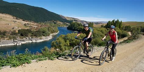
About
(10km cycle or walk, 13km boat cruise, 11km cycle or walk)
Pass under the Alexandra Bridge and beside historic (1882) bridge piers. Then, at the confluence of the Manuherikia and Clutha Mata-au rivers, enter the Roxburgh Gorge. Be amazed by the abrupt transition from urban to remote landscape against the awe-inspiring backdrop. Gaining height, the trail makes its way towards Butchers Creek, stone-walled water races, and other remnants of gold mining activity.
The trail stops beside the jetty at Doctors Point to meet the jet boat for an exciting and scenic trip down the Lake to Shingle Creek. Re-join the trail and journey on to complete the trail at Lake Roxburgh Hydro Dam.
(22km cycle or walk)
From the Roxburgh Dam lookout, the trail takes travellers into a rugged and isolated landscape with stunning northerly vistas across the Lake Roxburgh. Then, heading away from the water, the trail passes through a small secluded valley with regenerating Ka-nuka (tea tree) scrubland and into sweeping hill country farmland. At Elbow Creek, enjoy a gradual descent to Shingle Creek, the halfway mark. Rest up before returning to the hydro dam.
Commissioner's Flat to Roxburgh
(9.4km cycle or walk)
This section follows the banks of the mighty Clutha Mata-au River with its distinctive turquoise water, fast flow and ever changing eddies. Look out for signs of the 1880s' goldrush and imagine the conditions hardy settlers faced. Travelling downstream, carpets of orchards on both sides of the valley cut a swathe of colour whatever the season.
(19.6km cycle or walk)
Meander along the riverside, keeping an eye out for stunnng hillside rock formations and large stands of regenerating native Ka-nuka (tea tree). Five kilometres beyond Roxburgh, enjoy a break - and a swim - at Pinders Pond.
(24.7km cycle or ride)
Journey on through pastoral farm land towards the tiny settlement of Millers Flat then through the remote and beautiful Beaumont Gorge, meeting up with the State Highway 8 at the Beaumont Bridge. On the way, visit the historic Horseshoe Bend suspension bridge, and for added intrigue, a short detour from the bridge car park reveals the site of the famed Lonely Graves.
(19.4km cycle or walk)
From Beaumont, the trail begins its climb towards the highest point of the trail and on through Big Hill Tunnel. Beyond the tunnel descend into lush green farmland, crossing the highway several times. Along the way, see reminders of the area’s history: the discovery of gold, the milling of flax fibre for rope making (Evans Flat) and the arrival of Chinese prospectors to the goldfields (approaching Lawrence).


