Whangarei
17.89°C

Whangarei
17.89°C
Waitakere City
16.98°C
Manukau City
17.11°C

Papakura
24.46°C
Hauraki
17.26°C

Waikato
17.67°C
Matamata
18.46°C
Hamilton
17.51°C
Otorohanga
18.52°C
Rotorua
16.6°C
Taupo
15.44°C
Tauranga
19.27°C
Kawerau
18.6°C
Whakatane
19.64°C
Gisborne
15.51°C
New Plymouth
16.98°C

Stratford
8.97°C
Ruapehu
14°C
Wanganui
17°C
Palmerston North
16.41°C
Wairoa
19.19°C
Hastings
18.84°C
Napier
18.49°C
Masterton
15.49°C
Carterton
15.66°C
Porirua
15.99°C
Lower Hutt
16.45°C

Wellington
15.79°C

Tasman
9.35°C
Nelson
16.27°C
Marlborough
3.22°C
Kaikoura
15.48°C
Christchurch
12.59°C
Ashburton
12.52°C
Timaru
13.37°C
Waitaki
11.32°C
Waimate
13.08°C

Queenstown
12.38°C
Dunedin
14.33°C
Southland
9.98°C
Gore
11.31°C
Invercargill
12.06°C
Blenheim
14.73°C
Te Anau
27.35°C
Wanaka
11.17°C
Kaikoura
13.38°C
Stratford
13.54°C
Upper Hutt
15.9°C
About
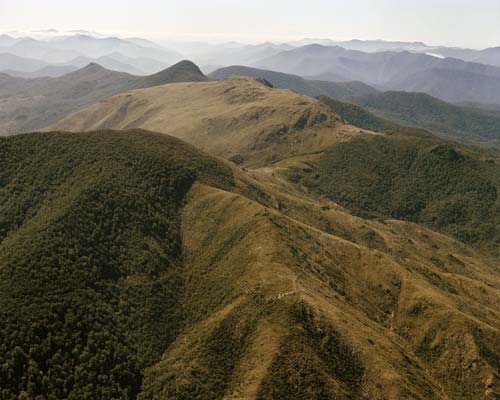
Dun Mountain (1129 m) is located on the Bryant Range, southeast of central Nelson. It is the namesake of the popular Coppermine Trail, as well as the Dun Mountain Mineral Belt and dunite, the ultramafic rock which the latter largely comprises. A return trip to the summit is a full-day walk from Maitai Dam, typically via a circuit combining Coppermine Trail and Rush Pool Track.
Dun Mountain is accessed from the end of Maitai Valley, which is 11 km up Maitai Valley Road from central Nelson. Use the car park just after Maungatapu Road turnoff, or if the gate is open, continue to the car park on the other side of the dam spillway. Take note of the signage that warns the gate will be closed at 5 PM.
You can climb to the summit via either of two tracks; Coppermine Trail or Rush Pool Track. Coppermine Trail is by far the more popular of the two and is less arduous, though as they both start at Maitai Dam and are roughly the same length, it’s a good idea to create a circuit out of both.
The majority of the circuit is within Nelson City Council’s Maitai Water Reserve. Along the top of Bryant Range between the Dew Lakes junction and Dun Saddle, the track skirts back and forth across the Mt Richmond Forest Park boundary, which roughly follows the top of the range.
This circuit can be completed in either direction.
From the dam car park, head along the gravel road on the other side of the gate, which climbs steadily through a block of recently-felled pine forest before gaining the top of a spur. Here, Rush Pool Track branches off to the right and continues through mineral belt scrub to the Rush Pool and a historic Maori argillite quarry. The Rush Pool was created by Maori in the 16th century to help quarry argillite. The quarrying process involved lighting a fire beneath rock outcrops to heat them, then dousing the rock with cold water from the pool, causing shards to split and crack off. A return trip to the Rush Pool alone will take you around 2 hr 30 min.
The track continues uphill, alternating between beech forest and mineral belt scrub. It is very rutted in places, and at times is literally a creek bed. You will reach a T-junction with Dun Saddle-Maungatapu Saddle Track at the top of Bryant Range (940 m elevation) after 2-3 hours. Turn right (south) at the junction to continue toward Dun Mountain. Dew Lakes are located 1 min north of the junction (to the left).
The top of the range is forested and flat, though quite boggy in places. The track climbs steeply over Little Twin (1143 m) before dropping down into a saddle. The stark boundary between beech forest and scrub at the saddle marks the beginning of the mineral belt. From here the track climbs up onto the Dun Mountain summit ridge to the summit (1129 m) which is marked by a cairn. Enjoy the magnificent views along Bryant Range and out to Tasman Bay.
Continue along the summit ridge (you will pass Dun Mountain shelter) and drop steeply down to Dun Saddle (930 m). Turn right and follow the rocky track on the right side of the gully. After 800 m you’ll reach the connection with Coppermine Trail. It is downhill for the remainder of the distance to Maitai Dam. Be wary of MTBs that may approach quickly from behind (though they should be the ones looking out for you). The track descends the western flank of Dun Mountain, then zig-zags into the valley of Maitai River South Branch. Once you cross the bridge across the river, it’s an easy 3.3 km back to where you started at Maitai Dam.


