Whangarei
17.89°C

Whangarei
17.89°C
Waitakere City
16.98°C
Manukau City
17.11°C

Papakura
24.46°C
Hauraki
17.26°C

Waikato
17.67°C
Matamata
18.46°C
Hamilton
17.51°C
Otorohanga
18.52°C
Rotorua
16.6°C
Taupo
15.44°C
Tauranga
19.27°C
Kawerau
18.6°C
Whakatane
19.64°C
Gisborne
15.51°C
New Plymouth
16.98°C

Stratford
8.97°C
Ruapehu
14°C
Wanganui
17°C
Palmerston North
16.41°C
Wairoa
19.19°C
Hastings
18.84°C
Napier
18.49°C
Masterton
15.49°C
Carterton
15.66°C
Porirua
15.99°C
Lower Hutt
16.45°C

Wellington
15.79°C

Tasman
9.35°C
Nelson
16.27°C
Marlborough
3.22°C
Kaikoura
15.48°C
Christchurch
12.59°C
Ashburton
12.52°C
Timaru
13.37°C
Waitaki
11.32°C
Waimate
13.08°C

Queenstown
12.38°C
Dunedin
14.33°C
Southland
9.98°C
Gore
11.31°C
Invercargill
12.06°C
Blenheim
14.73°C
Te Anau
27.35°C
Wanaka
11.17°C
Kaikoura
13.38°C
Stratford
13.54°C
Upper Hutt
15.9°C
About
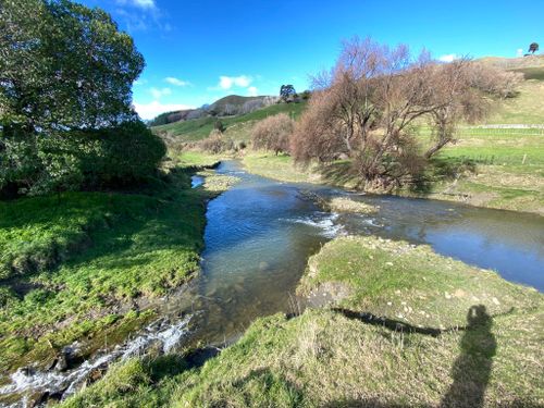
The walk commences at the left of a highway rest area and descends a set of steps to the tunnel entrance (walkers are not advised to enter the tunnel as the old concrete structure is now in an unsound condition). From this point the walk follows the clearly visible railway formation across open farm land for 2 km before crossing the Waihuka river alongside the concrete piers of an old railway bridge.
The walk from here continues through the hill cuttings and benchings made with pick and shovel by the railway workers some 80 years ago. Wooden culverts, large concrete sumps, fish plates and spikes can be seen along the walk.
After passing through the light bush on the edge of the Otoko Scenic Reserve, where spectacular yellow-flowering kowhai can be seen in the spring, the walkway leaves the railway formation. The tracks turns left down a farm vehicle track, follows the Waihuka river for a short distance and finishes at the State Highway opposite the Otoko Hall. Before making the turn down the farm track a short walk along the railway line offers views of a small picturesque waterfall set among native bush.


